Sunday closed beautiful and dry over Richmond, with high pressure centered over the south-central U.S. expanding east and weak northwest flow aloft keeping us seasonably cool. Monday a dry cold front pushes south through that calm — no rain, but northwest gusts of 15-25 mph behind it make mid-60s highs feel like the upper 50s, and Monday night turns into the coldest night of the stretch, with lows in the 30s for most places. Then high pressure slides east, the flow turns zonal, and Tuesday and Wednesday rebound to around 70 and dry — a mild pause before a much stronger front late in the week.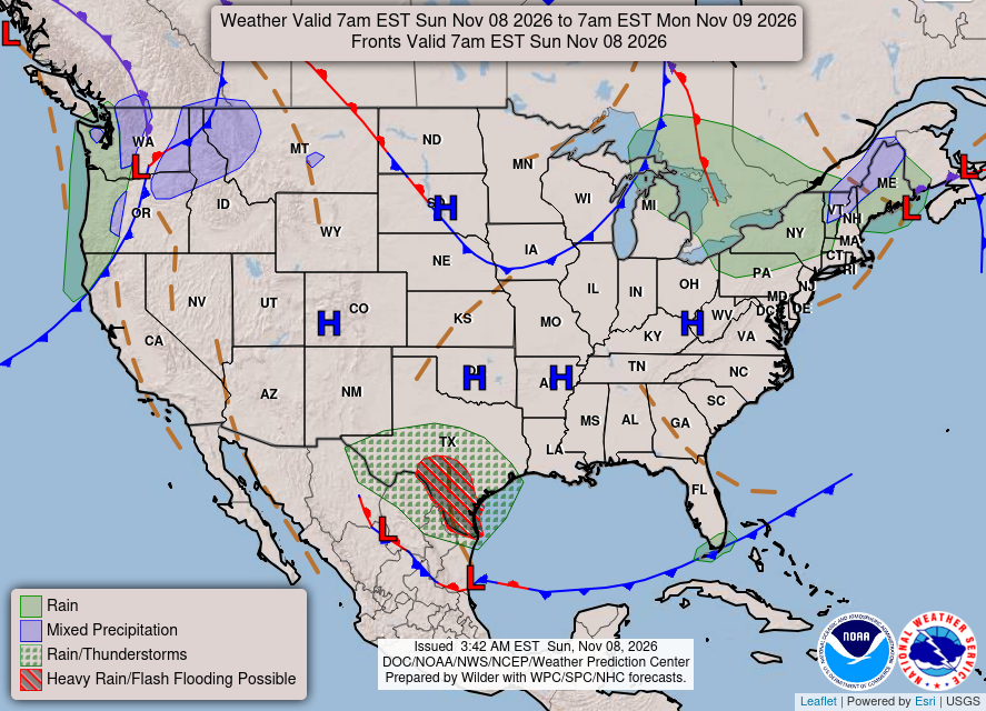
KEY HIGHLIGHTS
💨 A dry, breezy front Monday: A dry cold front crosses tonight-Monday with no rain for land areas. Highs reach the mid 60s Monday, but northwest gusts of 15-25 mph keep it feeling like the upper 50s; Small Craft Advisories run tonight through Monday for the Chesapeake Bay and coastal waters only.
🥶 The coldest night comes Monday night: Winds drop in time for efficient radiational cooling — lows in the 30s for most places, from the mid 30s in the Piedmont to the upper 30s in the metro and the Northern Neck, and low 40s immediately near the coast on the Lower Eastern Shore.
🌡️ Near 70 Tuesday-Wednesday, then a late-week turn: High pressure and zonal flow lift highs to around 70 both days, dry throughout. A strong cold front brings rain chances Thursday-Friday — models have trended drier — with below-average cold behind it: highs in the low-mid 50s this weekend and lows around freezing away from the coast.
How cold does Monday night get at yours?
SPECIAL FOCUS: The High That Couldn't Quite Get In
For days, high pressure has been trying to build fully into the Mid-Atlantic and getting held at the door — low pressure north of the Great Lakes and another system near Nova Scotia block it, leaving us under weak northwest flow and a trough over New England. That is why this dry stretch stays cool instead of warming up. Monday's dry front is the block shifting, not breaking: it sweeps through rain-free, then parks high pressure to our south. Translated into plain English: once the high settles south of us and the flow aloft flattens out — zonal, west to east — nothing pushes back, so temperatures simply drift up to around 70 Tuesday and Wednesday.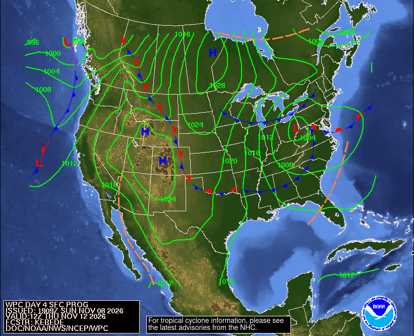
What could change this: Thursday-Friday rain is trending drier — ensembles put even a 0.50-inch total as unlikely, with the best chance for appreciable rain north of I-64 Thursday evening through Friday.
DETAILED FORECAST
Monday (Nov 9): Sunny and dry behind the front, high in the mid 60s in the metro and Piedmont, low to mid 60s on the Northern Neck and Lower Eastern Shore. Northwest winds gust 15-25 mph in the afternoon, so it feels like the upper 50s. Low in the upper 30s in the metro, mid 30s in the Piedmont, low 40s at the immediate coast. The breezy reset — jackets earn the gusts, then the cold settles in.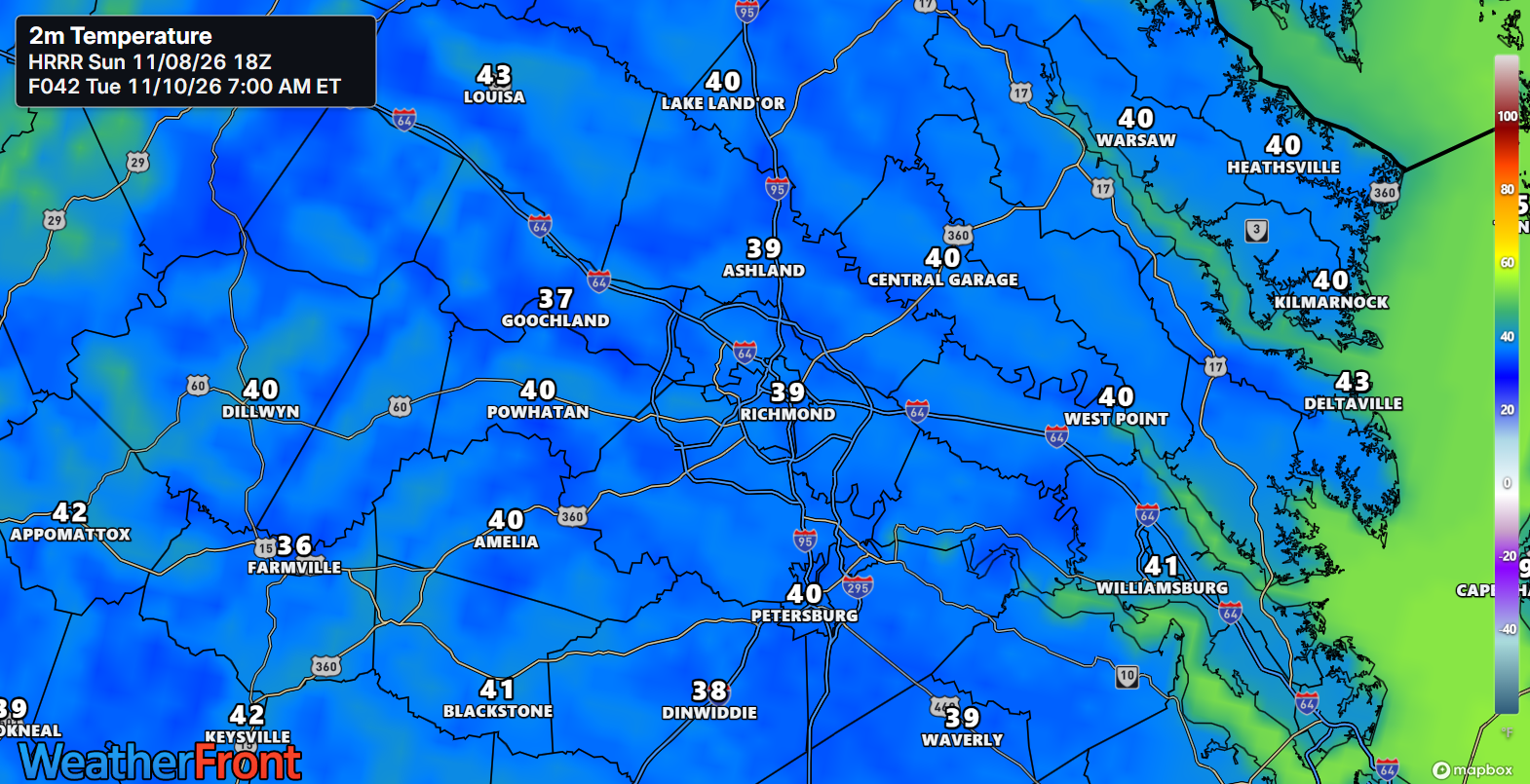
Tuesday (Nov 10): Sunny and milder as high pressure slides east, high around 70 in the metro and Piedmont, upper 60s on the Northern Neck and Lower Eastern Shore, light southwest winds around 10 mph on the waters. Low in the low to mid 40s. Dry all day. The rebound — November briefly forgets itself.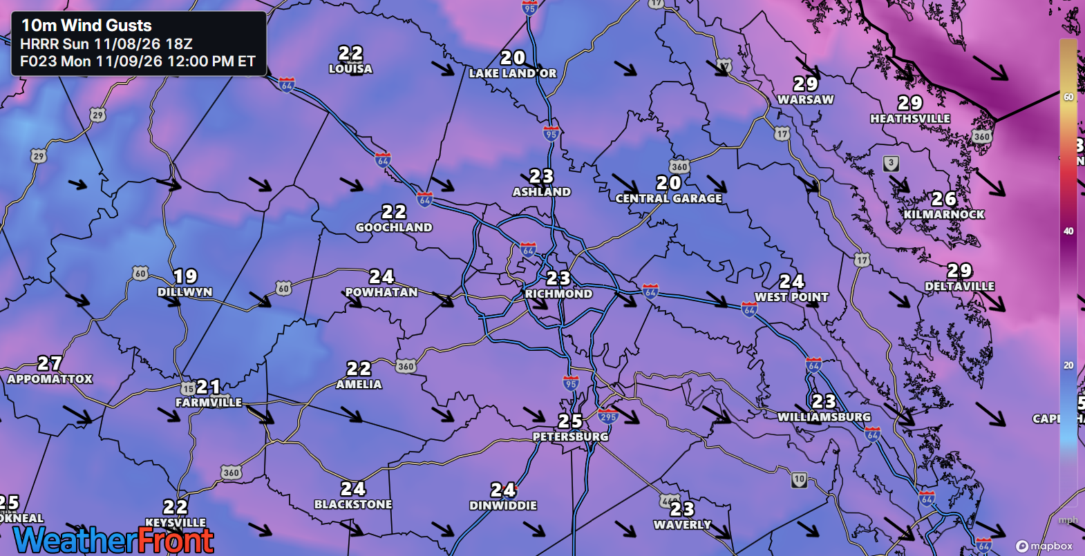
Wednesday (Nov 11): Mostly sunny and mild, high around 70 regionwide, a touch cooler at the immediate coast, light and variable winds. Low in the mid 40s as clouds begin to gather well ahead of Thursday's system. Dry for Veterans Day plans. The calm, warm pause before the late-week turn.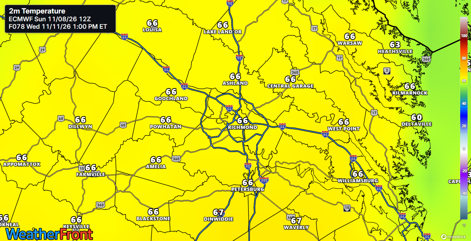
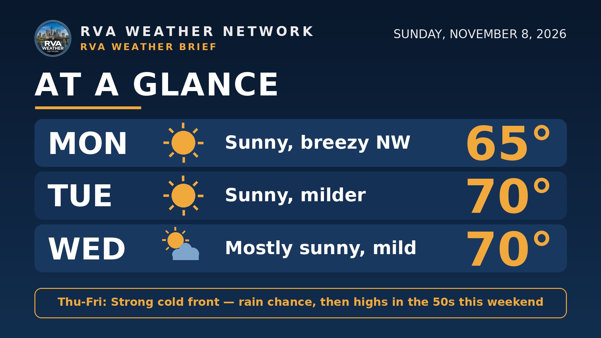
AT A GLANCE
Mon: Sunny, breezy NW — 65°
Tue: Sunny, milder — 70°
Wed: Mostly sunny, mild — 70°
Thu-Fri: Strong cold front — rain chance, then highs in the 50s this weekend
SPECIALIZED CALLOUTS
🌱 Gardening & Soil Brief: Monday night is the protection night — lows in the 30s for most places mean tender plants come in or get covered Monday evening, especially in the Piedmont. The dry stretch runs through Wednesday, so keep watering new plantings even after Friday's soaking.
🚗 Commute & Outdoor Rating: 9/10. Three dry days, no rain and no fog expected, with full sun Tuesday and Wednesday. The only deduction is Monday afternoon: northwest gusts of 15-25 mph on bridges and exposed roads.
🏠 Home & Energy Brief: Heating works hardest Monday night, with lows in the 30s — a good night to check the furnace filter before the colder weekend ahead. Tuesday and Wednesday near 70 ease daytime heating, and lows recover to the 40s.
🚴 Two-Wheel & Runner's Outlook: Monday is a headwind day — northwest gusts of 15-25 mph on exposed stretches, and a cold start Tuesday morning in the 30s and low 40s. Tuesday afternoon and Wednesday are the picks: dry, light winds, around 70.
COMMUNITY ENGAGEMENT
🌡️ Tuesday-morning thermometer check — how low did Monday night go at your house? Reply with your low — 34, 38, 42, or 45+ — plus your neighborhood, so we can map the cold pockets from the Piedmont to the Shore. Full reports at https://rvaweather.net/obs. Like this if you covered plants Monday night — did the cover actually matter?
📩 Share & Subscribe: Send this to anyone making Veterans Day plans Wednesday or weekend plans that assume 60s — Friday's front changes the weekend math. Get the brief in your inbox: https://rvaweather.net/newsletter
Thanks for reading the RVA Weather Brief — 100% free, from the RVA Weather Network team. Support our work at https://rvaweather.net/social. Built on the latest NWS Wakefield forecast discussion (2:34 PM EST Sun Nov 8, 2026 — the latest available at generation time; no post-3:00 PM discussion had been issued yet), with local context from the RVA Weather Network team. Keep an eye on the sky — and stay safe out there.