From Record Heat to Holiday Chill: The Massive Weather Flip Heading Our Way
Substack
May 19, 2026, 9:00 PM
From Record Heat to Holiday Chill: The Massive Weather Flip Heading Our Way

This evening, warm south-southwesterly breezes are keeping the region incredibly mild, offering little relief after a day of blistering, near-record heat. If you felt like today was unusually scorching, your instincts were spot-on. Fresh off breaking a 115-year-old record on Monday by hitting 96°F, Richmond is once again flirting with record-high territory today as temperatures climbed into the low-to-mid 90s across the interior.

Expect a sticky, warm night ahead, with temperatures only bottoming out in the upper 60s to lower 70s.
Wednesday: One Last Bake Before the Front
Tomorrow will feel like a carbon copy of today—if not slightly hotter. Thanks to a phenomenon called compressional heating (where air warms as it gets squeezed ahead of an incoming cold front) combined with ongoing drought conditions, temperatures will skyrocket into the mid-to-upper 90s inland and the lower 90s right along the coast.

Because the ground is so dry, morning moisture will quickly “mix out” by the afternoon. While lower humidity might sound like a relief, it will actually allow the ambient air to heat up even faster.
The Wednesday Night Storm Threat
By Wednesday afternoon, a strong cold front will begin its approach from the northwest. For anyone hoping for a widespread, drought-busting rain, the latest weather models bring a bit of a letdown: the front is slowing down.

Here is what you need to know about the timing and storm potential:
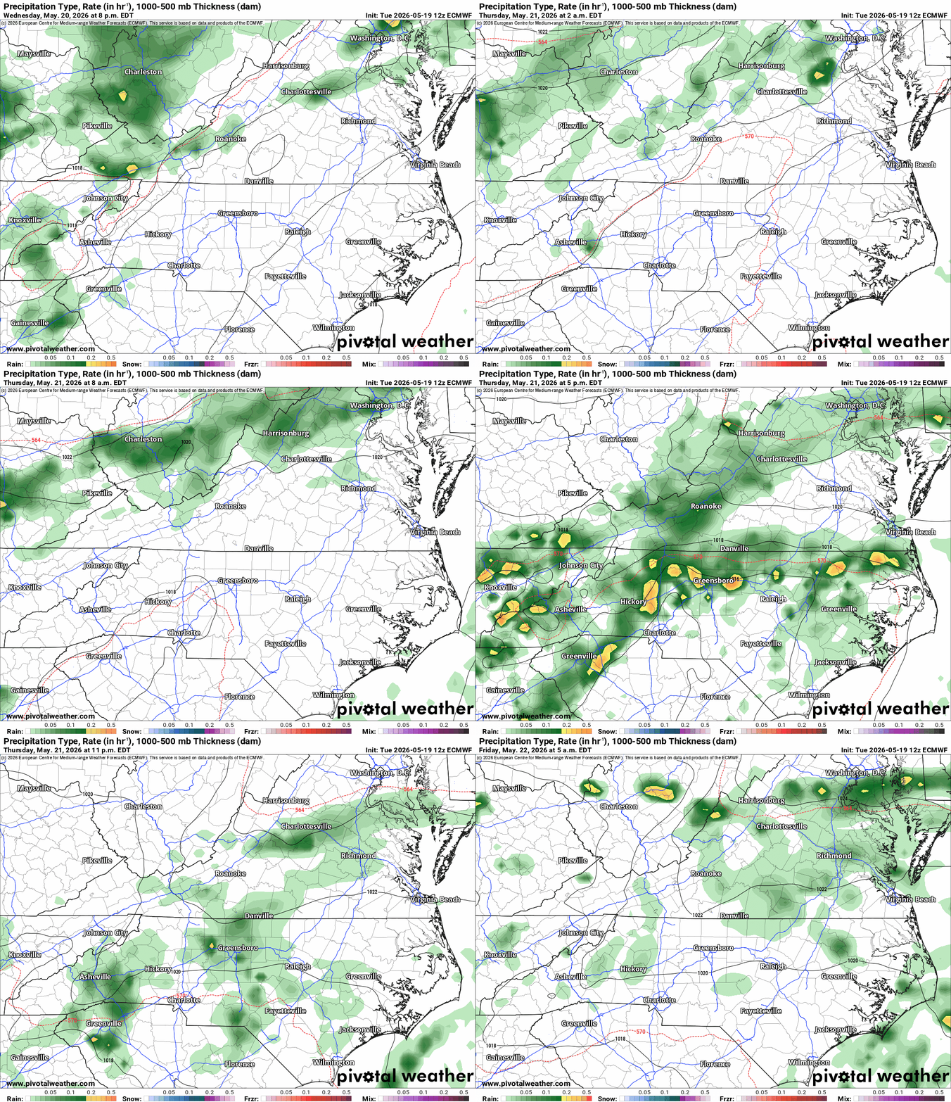
The Timing: Showers and storms will fire up to our northwest on Wednesday afternoon, but will struggle to make forward progress. High-resolution models suggest this activity will stay entirely out of the Richmond metro area through most of Wednesday evening, likely holding off until late Wednesday night for northern counties, and delaying until Thursday morning for areas south of US-460 and into Northeast North Carolina.
The Risk Zone: The Storm Prediction Center has placed the northern half of our area under a Level 1 out of 5 (Marginal) Risk for severe weather.
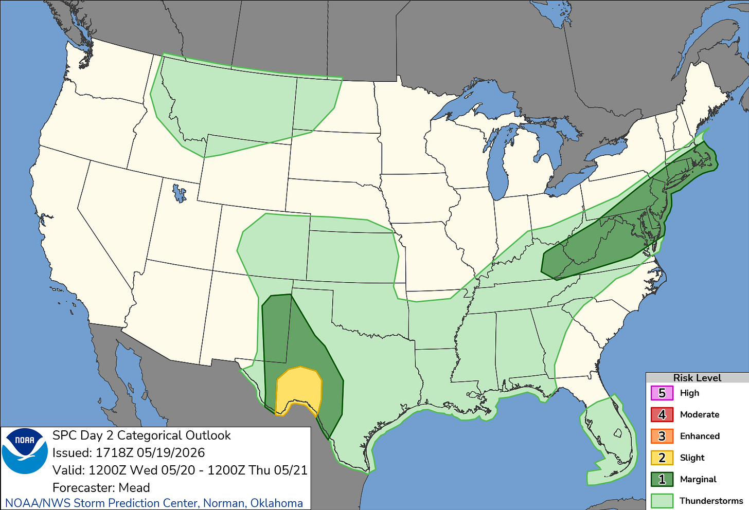
The Impacts: The primary dynamics and atmospheric energy are tracking well to our north, meaning storms will likely begin to lose their punch and dissipate as they cross into our local area. However, areas north of Richmond, the Northern Neck, and the Maryland Eastern Shore could still see a few stronger clusters. Damaging wind gusts are the primary threat, though an isolated instance of large hail can’t be completely ruled out.


The Holiday Weekend Flip: Enter the “Wedge”
If you have outdoor plans for the upcoming holiday weekend, you’ll want to pay close attention to a major shift in the long-range forecast.
Once the cold front clears the region on Thursday morning, a powerful, cool high-pressure system will settle over the Great Lakes and Eastern Canada. This will push the front south into the Carolinas, where it is expected to stall out on Friday.
What follows is a classic mid-Atlantic weather pattern known as a Cold Air Damming (CAD) wedge. Cool, damp air will get trapped against the mountains and funnel directly into our region from the northeast.
https://www.wral.com/story/ask-the-meteorologist-how-is-cold-air-damming-making-it-feel-more-like-fall-in-north-carolina/22024718/
The Holiday Weekend Outlook: Moisture riding over top of this cool air mass will cause rain chances to ramp up quickly late Thursday into Friday. Friday looks damp, cloudy, and downright chilly, with high temperatures struggling to get out of the 60s to low 70s—a massive 30-degree drop from Wednesday.

There is still considerable model uncertainty regarding the upcoming weekend. The latest trends suggest this stubborn, cool air mass may linger through much of Saturday and potentially Sunday before a warm front can slowly lift back north to erode it. As a result, expect an unsettled, cooler, and wetter holiday weekend than originally anticipated, with the front remaining draped across our northern counties into early next week.
Marine & Beach Outlook
For those planning to hit the water or the sand, conditions will change dramatically over the next 48 hours.
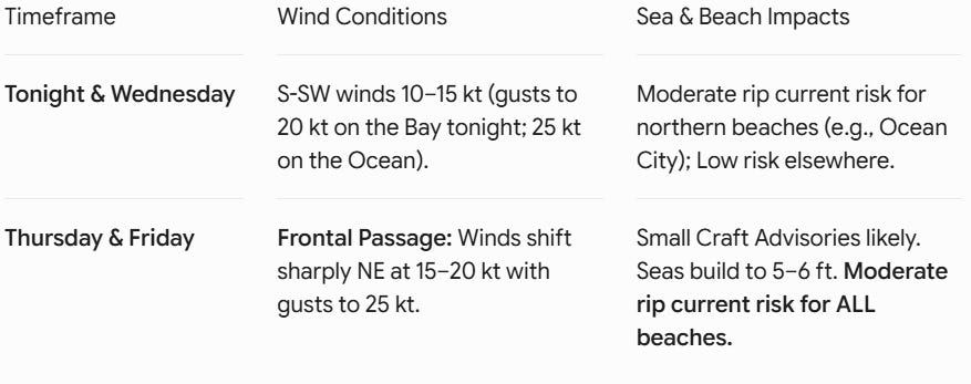
Winds are expected to diminish and become more variable by Saturday and Sunday as the pressure gradient relaxes, though damp conditions may persist. Keep the umbrella close by, and stay tuned for updates as we get closer to the weekend.

Comments
(0)No observations yet. Be the first to share!