Needed Rain is on the Way: Tracking This Week's Thunderstorm Potential
Substack
May 24, 2026, 2:01 PM
Needed Rain is on the Way: Tracking This Week's Thunderstorm Potential

This evening, keep an eye on the radar. Unsettled weather is officially moving in and will stick around through midweek, bringing daily chances for showers and thunderstorms.

If you woke up this morning to gray skies and a thick layer of pea-soup fog, you can thank a stubborn weather phenomenon known as “cold air damming”—or simply “the wedge.” High pressure sitting near Nova Scotia has been funneling cool, damp marine air right against the mountains, trapping a moist low-level air mass over most of our region. Visibility dropped to less than a mile in some spots early today, especially along the coast.

The good news? This stubborn wedge is finally starting to break down. A warm front is slowly lifting northward, but if past days are any indication, weather models usually try to clear this out way too fast.

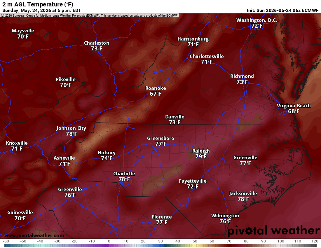
Expect the Piedmont region to cling to those cooler temperatures and stubborn clouds well into the afternoon, while central and southeastern areas break into a much warmer, stickier airmass.
That warm, humid air will provide the fuel for our evening weather transition.
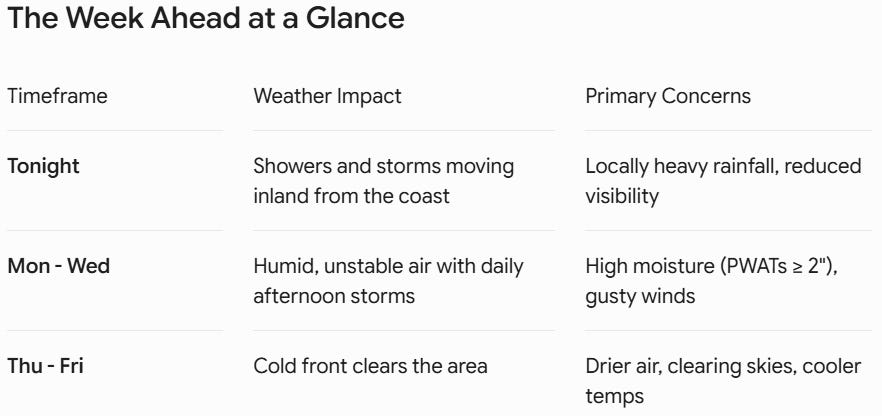
What to Expect: Sunday Night into Midweek
As that warm front pushes north, showers and thunderstorms are expected to fire up late this afternoon along the North Carolina coastal plain and smaller-scale sea breeze boundaries. This evening and into early tonight, that activity will progress northward into the rest of our area.

The Good News: Severe weather is not expected. The Catch: These storms will be packed with moisture. Locally heavy rainfall is the primary threat tonight, and additional waves of showers will linger into the overnight hours.
Monday through Wednesday look downright tropical. We are tracking a highly unstable airmass with Precipitable Water (PWAT) values—a measure of how much moisture is locked in the atmosphere—nearing or exceeding a hefty 2 inches.

The silver lining here is that we genuinely need the rain. Because our soils have been so dry lately, we aren’t anticipating widespread flooding concerns, though the Weather Prediction Center (WPC) has placed us under a marginal risk for excessive rainfall each day. While widespread severe weather isn’t on the docket, don’t be surprised if a few stronger storms dump heavy water and unleash brief, gusty downbursts.

A Midweek Heat Peak and Late-Week Relief
Temperature-wise, it’s going to be a bit of a roller coaster depending on where you live:
Today (Sunday): Highs will range from the chilly low-to-mid 70s in the western Piedmont to the low 80s further east.
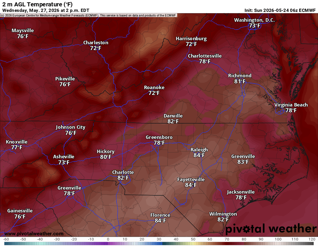
Monday - Wednesday: Mild and warm, though the nearby front might wobble back and forth, causing some local temperature swings. Wednesday and Thursday will easily be the warmest days of the week, with afternoon highs surging deep into the mid-to-upper 80s.
Friday & Beyond: Relief arrives just in time for the end of the workweek. A deep upper-level trough digging out of eastern Canada will finally drag a cold front through the region, ushering in much drier air and lowering our rain chances significantly by Friday.


Aviation & Marine Notes
For the Pilots: Expect a slow improvement from IFR/LIFR ceilings up to MVFR this afternoon as the front lifts north. However, scattered thunderstorms this evening will cause sudden drops in visibility, and widespread flight restrictions are likely to return late tonight.
For the Mariners: Small Craft Advisories (SCAs) remain in effect through this evening across the coastal waters due to elevated, choppy seas ranging from 4 to 8 feet (highest to the north). Winds will drop and become rather light and variable by Monday and Tuesday as the boundary lingers over the Mid-Atlantic coast.
Stay tuned for further radar updates as the storms begin to cross the border later today! As always, check out rvaweather.net for the latest and stay safe out there!

Comments
(0)No observations yet. Be the first to share!