Tonight's Surprise Deep Chill (And the 90s Waiting on the Other Side)
Substack
Jun 2, 2026, 9:16 PM
Tonight's Surprise Deep Chill (And the 90s Waiting on the Other Side)

This evening, the air outside feels a whole lot more like early April than the first week of June.
If you stepped outside today and found yourself reaching for a light jacket, you aren’t alone. An unseasonably strong area of high pressure parked over the Great Lakes—clocking in at the 99th percentile for this time of year compared to historical climate data—has completely hijacked our weather. Between a cold air mass sitting high in the atmosphere and gusty northeast winds topping 30 mph at the coast, temperatures today struggled to even make it out of the 60s near the water, capping off in the ultra-crisp upper 60s and low 70s further inland.

But change is already moving in. Those howling winds are expected to rapidly diminish over the next few hours, setting us up for a remarkably quiet, clear, and chilly night.
While the standard National Blend of Models (NBM) guidance points to lows in the lower 50s inland and upper 50s at the coast, the atmosphere has a sneaky setup for a deeper chill. Because our current dew points are sitting in the bone-dry upper 30s and low 40s, the combination of clear skies and dying winds is going to allow the ground to lose heat fast. Do not be shocked if many inland locations outside of our major urban centers wake up to temperatures in the upper or even mid-40s tomorrow morning. (In fact, specific MAV guidance for Louisa County/LKU is already spitting out a projected low of 46°F).

The Week Ahead: A Major June Turnaround
Enjoy the sweater weather while it lasts, because a classic summer comeback is already timing out its arrival.

The weather pattern holding this chill in place (a blocked upper-level system known as a Rex Block) will begin breaking down overnight. This allows the high-pressure ridge currently over the Upper Midwest to slide southeast, eventually centering itself directly over the Southeastern U.S. by Friday.

As that ridge builds, temperatures will climb step-by-step:
Wednesday: The warmup commences. Expect inland areas to rebound into the upper 70s and lower 80s. The coast will stay noticeably cooler due to a lingering northeast breeze.
Friday: We push the envelope toward real summer warmth, hitting the upper 80s with a few spots likely tagging the lower 90s.
The Weekend: Widespread lower 90s return, giving us a perfectly typical, hot June weekend.
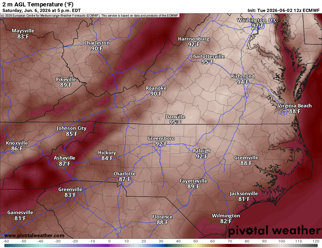

If you are looking for rain to help the lawn, you are going to have to wait a while. Our next realistic chance for showers or storms doesn’t arrive until later Sunday afternoon or Monday as the ridge weakens and a weak frontal boundary tries to slide through. Right now, long-range models are pretty unenthusiastic about rainfall totals; multi-model ensembles show only a slim 25% probability of picking up a quarter-inch or more of rain.

Looking ahead to next Monday and Tuesday, the forecast gets incredibly fuzzy. There is a massive spread in the data (with potential high temperatures ranging anywhere from the mid-70s to the lower 90s) because meteorologists are still parsing out exactly where that front will stall and how much cloud cover it will drag along with it.

Marine & Aviation Outlook
For the Pilots: It’s blue skies ahead. Expect beautiful VFR (Visual Flight Rules) conditions across all regional terminals for at least the next 24 hours, and likely persisting through Saturday night. Those bumpy, gusty northeast winds will rapidly drop off early tonight, remaining light and much more manageable through Wednesday.
For the Boaters & Beachgoers: Conditions on the water remain rough for the time being, but relief is on the way. Small Craft Advisories remain in effect through this evening for the lower Chesapeake Bay, lower James River, Currituck Sound, and the northern coastal waters as northeast winds run 15–25 knots with gusts to 30 knots.

While the winds will slacken to a gentle 5–10 knots overnight and shift northwest, the ocean will take longer to calm. Seas are currently cresting at a massive 7–10 feet off Virginia Beach and the North Carolina Outer Banks. Because of that lingering heavy swell, Small Craft Advisories remain in effect for the southern coastal waters into Wednesday.
If you are heading to the beaches over the next 48 hours, be incredibly careful. A High Surf Advisory is in effect through this evening for the Currituck Outer Banks, and we will carry an elevated rip current risk through Wednesday and potentially Thursday. Expect a Moderate Risk for northern beaches and a High Rip Current Risk for southern beaches.

By Friday and into the weekend, high pressure moves offshore, giving way to light, variable winds that will eventually settle into a standard, sub-advisory summer south-southwesterly flow.
Want to stay ahead of the weather? Head over to rvaweather.net for your latest, hype-free local updates! 🌤️
Don’t forget—you are my eyes and ears on the ground. Got a backyard thermometer reading, rain gauge total, or a picture of the sky? Submit your own weather observations right on the site and join the crew!
As always, keep an eye on the sky and stay safe out there! 👋
Comments
(0)No observations yet. Be the first to share!