Beat the Heat: Why This Weekend's 90-Degree Forecast Won't Feel Like Summer (Yet)
Substack
Jun 4, 2026, 9:09 PM
Beat the Heat: Why This Weekend's 90-Degree Forecast Won't Feel Like Summer (Yet)

This evening is shaping up to be absolutely gorgeous across the Mid-Atlantic. If you have outdoor plans, you couldn’t ask for better conditions. High pressure is sitting right over us, leaving us with crystal-clear skies, calm winds, and incredibly comfortable air.

Temperatures tonight will drop into a crisp mid-50s to lower 60s (with a few of our typical cool spots even flirting with the lower 50s). Open the windows and skip the AC for one more night—because big changes are coming tomorrow.

Starting Friday, summer is cranking up the thermostat.
Here is what you need to know to plan your upcoming week.
1. The Heat is On (But the Humidity is Delayed)
The high-pressure system that gave us a beautiful Thursday is moving offshore, opening the floodgates for a major warming trend.
Friday: Expect widespread highs in the lower 90s under sunny skies.
Saturday: This looks to be the hottest day of the stretch. We are tracking afternoon highs climbing into the lower-to-mid 90s.
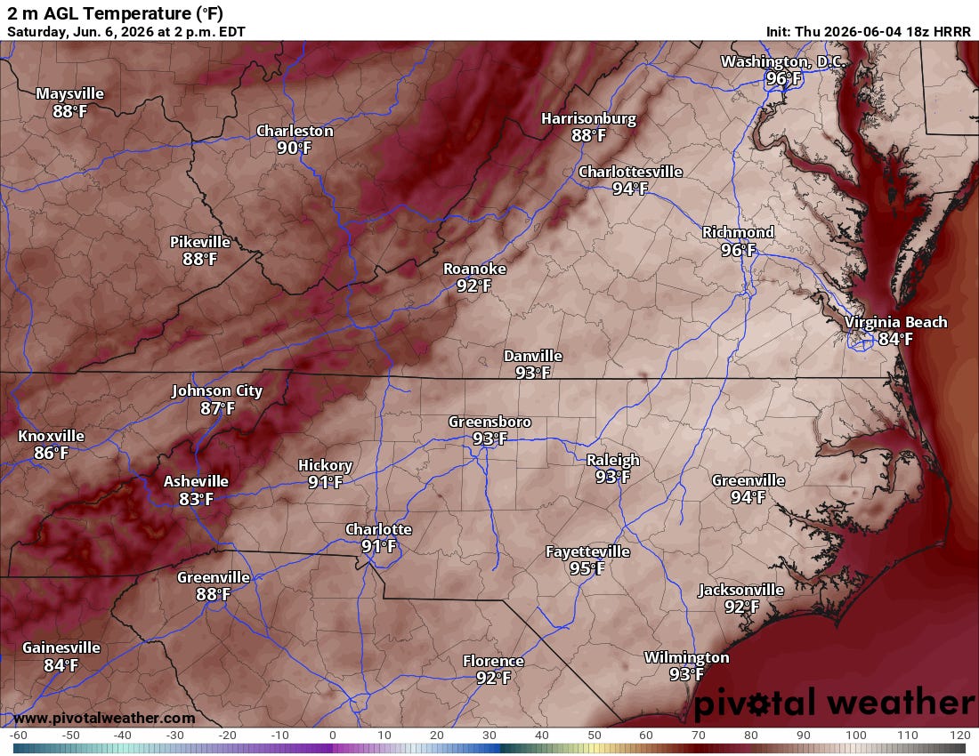

The Good News: Usually, June heat in the Mid-Atlantic comes with oppressive, sticky humidity. Fortunately, the dewpoints are going to struggle to recover over the next couple of days. Because the air will remain relatively dry, the “heat index” (what it actually feels like) should stay right around or even slightly below the actual air temperature. It’ll be hot, but not completely swampy just yet.

2. Sunday Storm Chances are Fading
If you were hoping for a soaking rain to help your lawn or garden, I have some tough news. The weather models have continued to trend downward regarding rain chances for Sunday afternoon and evening.

A cold front will be approaching from the north, and while it will likely trigger some scattered showers and thunderstorms later on Sunday, the overall coverage looks pretty limited. Right now, there is less than a 20% chance that any given spot sees a quarter-inch of rain.

A Quick Heads-Up: While rain will be hit-or-miss, the atmosphere will be quite warm and moderately unstable on Sunday. With stronger winds aloft, the few storms that do manage to fire up could become strong to severe. We will be keeping a close eye on that potential over the next couple of days.
3. The Outlook: A Refreshing Start to Next Week
Once that cold front clears out Sunday night, it’s going to usher in a beautiful stretch of weather for the first half of next week.
All the latest data indicate the front will clear the region completely by Monday. Behind it, a fresh northern high-pressure system will push cooler, much drier air into the region.

From Monday night all the way through Thursday morning, we are looking at a favored dry spell with very comfortable, below-average temperatures—especially by Tuesday. Enjoy it, because a renewed warming trend is lurking toward the end of next week!
Marine & Beach Outlook 🌊
Heading out on the water? The weekend looks fantastic, though boaters should keep an eye on Saturday night. We might see a brief overnight surge of southerly winds gusting up to 20–25 knots on the ocean, but waves should generally behave themselves under 5 feet.

The real shift happens from Monday to Tuesday. Once the cold front passes, a strong northeasterly onshore wind will develop. Expect rougher seas, choppy bay conditions, and likely some Small Craft Advisories early next week.
Have a great weekend, stay hydrated, and enjoy the sunshine!
Want to stay ahead of the weather? Head over to rvaweather.net for your latest, hype-free local updates! 🌤️
Don’t forget—you are my eyes and ears on the ground. Got a backyard thermometer reading, rain gauge total, or a picture of the sky? Submit your own weather observations right on the site and join the crew!
As always, keep an eye on the sky and stay safe out there! 👋
Comments
(0)No observations yet. Be the first to share!