Sunday Night Storms Usher in a Striking Cool-Down (Before the 90s Roar Back)
Substack
Jun 7, 2026, 7:50 PM
Sunday Night Storms Usher in a Striking Cool-Down (Before the 90s Roar Back)

This evening, the weather across our region is on the verge of a quick, dramatic shift. After enduring a hot Sunday afternoon under a blazing sun, a “backdoor” cold front—meaning it is pushing in from the northeast rather than the usual west—is on our doorstep.

If you are stepping outside tonight, here is exactly what you need to know about the fire risk, impending storms, and a brief, beautiful break from the summer heat before it returns with a vengeance.
1. The Immediate Threat: Fire Danger and Evening Storms
Before the relief arrives, we have a couple of weather hurdles to clear.
First, the North Carolina Forest Service has requested an Increased Fire Danger Statement for portions of Northeast North Carolina until 8:00 PM tonight. A stubborn combination of ongoing drought, bone-dry soil, and exceptionally low relative humidity (down to 25–35%) means that any spark could quickly get out of hand.

Second, that approaching cold front is going to spark scattered showers and thunderstorms.
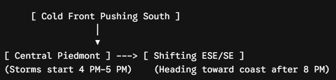
The Big Takeaway: Because these storms will be isolated to scattered, not everyone will see rain. But if a storm hits your backyard, it could pack a punch. The main threat tonight is damaging wind gusts, and a few lucky spots could walk away with a quick quarter to half-inch of much-needed water before everything tapers off around 2:00 AM.

2. Monday & Tuesday: A Dramatic, Brief Cool Down
Once the front clears the area overnight, high pressure will build in from New England, completely shifting our wind pattern. Cool, onshore winds will rush in from the ocean, giving us a magnificent two-day break from early-summer humidity.

The coastal areas will feel the biggest plunge:
Ocean City, MD: Highs likely won’t even break the upper 60s on Monday.
Virginia Beach, VA: Temperatures will struggle to push past 70°F.
Inland Areas: Expect a beautiful, comfortable day in the low-to-mid 80s (and potentially even cooler, staying in the upper 70s if current trends hold).
Monday night into Tuesday morning will feel downright crisp. With high pressure sitting right over the Eastern Shore, widespread lows will drop into the mid-60s.

3. The Long Range: Summer Bounces Right Back
Enjoy the breeze on Monday and Tuesday, because the atmosphere is throwing the switch right back to “sauna” by the end of the week.
By Wednesday, the high pressure moves offshore, shifting our winds back to the south. A massive upper-level ridge of high pressure will begin building over the Eastern U.S. By Thursday and Friday, we are looking at widespread mid-to-upper 90s.

To make matters stickier, this late-week heatwave looks unsettled, meaning we will likely fall back into a classic summer pattern of daily afternoon humidity-fueled showers and thunderstorms.

Marine Notice: If you are heading out on the water, a Small Craft Advisory goes into effect late tonight through Monday evening for the lower Chesapeake Bay, lower James River, and coastal waters south of Chincoteague, with northeast winds gusting 15–20 knots and seas building up to 4–6 feet offshore.

Stay weather-aware this evening, protect those dry areas from open flames, and get ready for a beautifully cool Monday morning!
Want to stay ahead of the weather? Head over to rvaweather.net for your latest, hype-free local updates! 🌤️
Don’t forget—you are my eyes and ears on the ground. Got a backyard thermometer reading, rain gauge total, or a picture of the sky? Submit your own weather observations right on the site and join the crew!
As always, keep an eye on the sky and stay safe out there! 👋
Comments
(0)No observations yet. Be the first to share!