Storms Tonight, Splendid Tomorrow: Your Early-Week Weather Reset
Substack
Jun 14, 2026, 8:33 PM
Storms Tonight, Splendid Tomorrow: Your Early-Week Weather Reset

This evening, we are tracking a brief but intense window for severe weather before a much-needed pattern shift brings a taste of comfortable, pleasant air to the region.
If you are out on the water or living along the Bayside of Maryland’s Eastern Shore, take note: a Coastal Flood Statement has been issued for tonight’s high tide cycle.
Here is everything you need to know about tonight’s storms and the beautiful week ahead.
Tonight: High Energy, Late Delivery
The entire area is currently under a Slight Risk (2 out of 5) for severe thunderstorms through this evening.

While the atmosphere is deeply juiced with high humidity and plenty of instability (CAPE values up to 3000 J/Kg for the tech-minded weather folks), a weak layer of warm air aloft has been capping the storms and keeping things isolated this afternoon.
That cap is about to break.
The Timing: Expect storm coverage and intensity to ramp up significantly between 5:00 PM and 9:00 PM as an upper-level trough pushes in from the west. The threat could linger for a few hours along the coast. There is currently an 80% chance that a Severe Thunderstorm Watch will be issued.
The Primary Threat: Straight-line damaging wind gusts. The atmospheric profile is perfectly set up for strong downbursts. While large hail is unlikely and storms are moving too fast for widespread flooding, local urban ponding and a brief, isolated spin-up near the coast can’t be entirely ruled out.
The Cold Front: The actual front sweeps through between 2:00 AM and 5:00 AM, scouring out the humidity and ending the severe threat.

For aviators and mariners, expect temporary flight restrictions (TEMPO groups are active at all major terminals) and a Small Craft Advisory for the Chesapeake Bay through Monday morning, as winds shift from the southeast to a gusty northwest push behind the front.
The Outlook: A Spectacular Start, A Stormy Sequel
Once we get past tonight, the weather rewards us with a phenomenal stretch of early-week comfort.
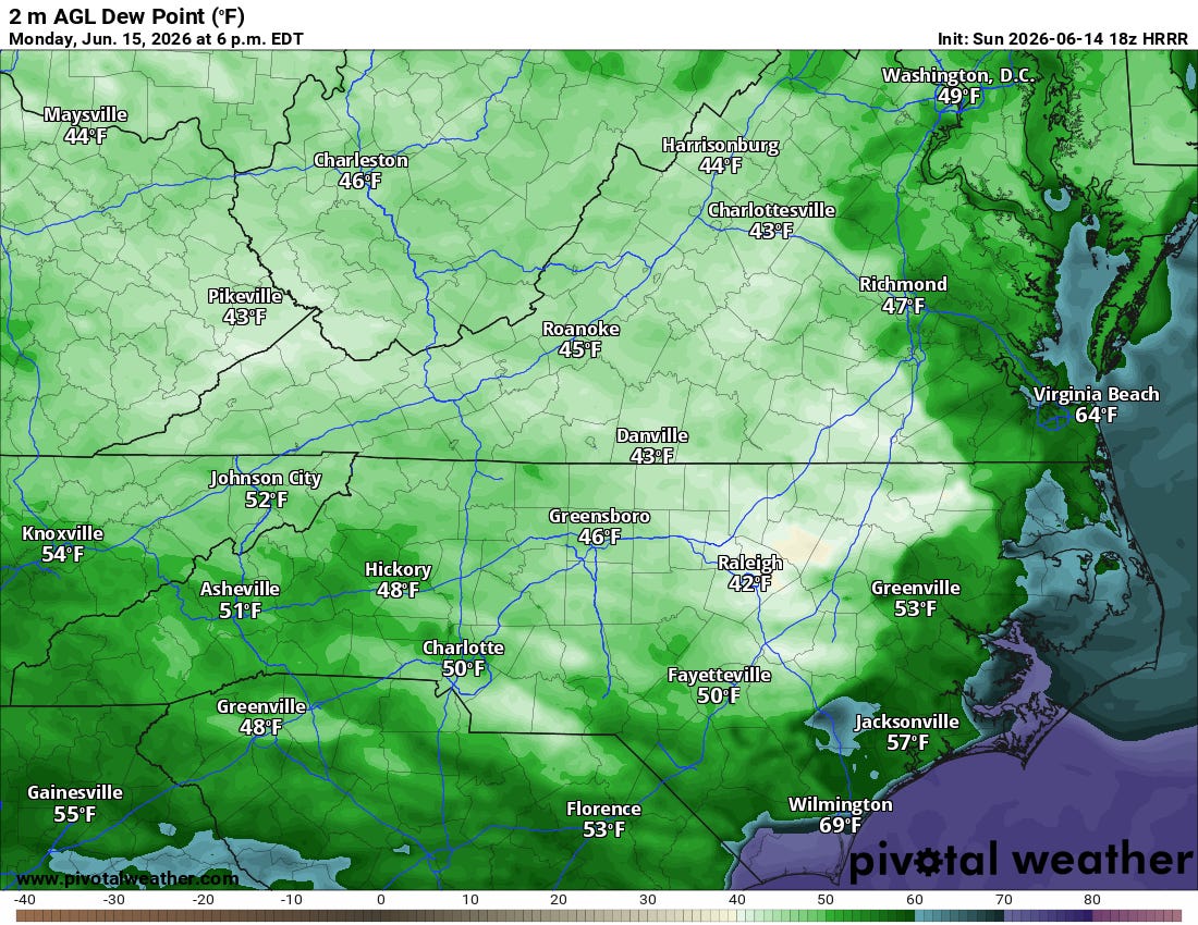
Monday: A total reset. Dewpoints will plunge into the 50s and low 60s. With partly sunny skies and highs in the low-to-mid 80s, it is going to feel incredibly comfortable for mid-June. Only the far southeastern portions of North Carolina face a lingering afternoon shower risk.
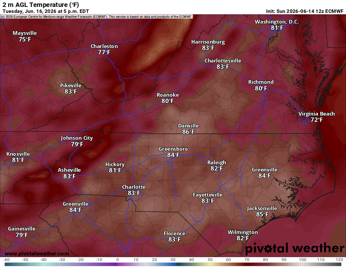
Tuesday: Clouds increase slightly as the stalled front to our south tries to lift back north. Expect cooler highs in the upper 70s to low 80s, with the best chance for scattered showers remaining down near the Albemarle Sound.
Wednesday & Thursday: The summer heat strikes back. The trough breaks down, pushing a warm front through the region. Humidity will surge, and by Thursday, temperatures may approach Heat Advisory criteria.
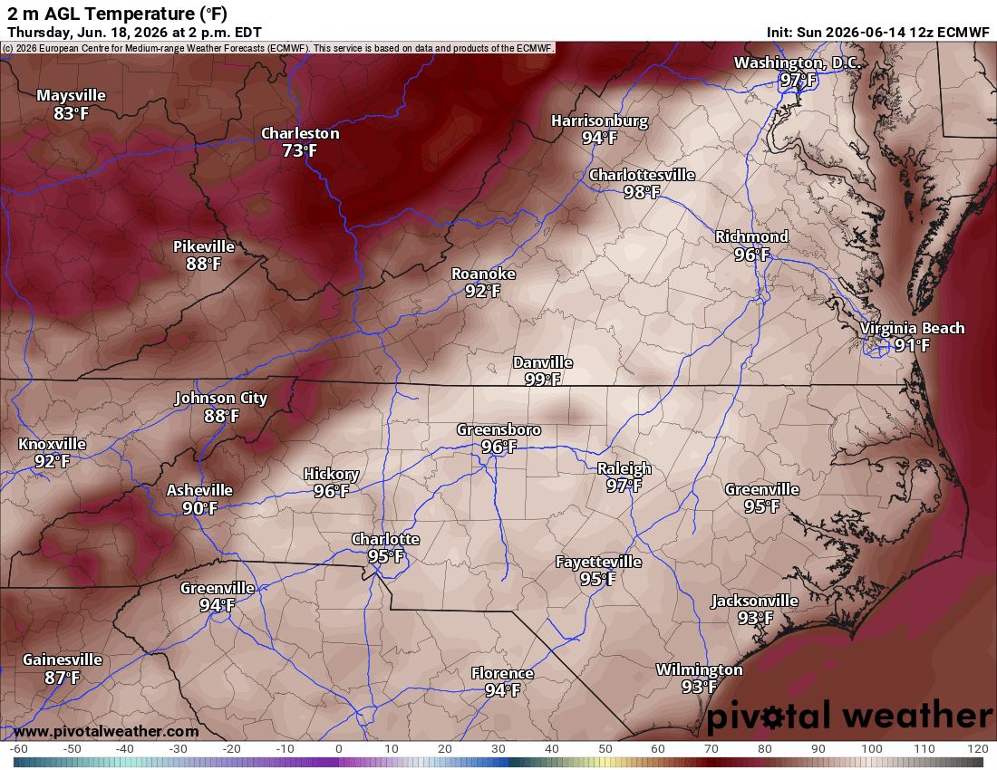


Keep your eyes on Thursday afternoon and evening. The Storm Prediction Center is already highlighting our northern counties in a Day 5 severe weather outlook. Another strong cold front will approach the area, threatening a round of potent storms to close out the work week.

Enjoy the refreshing air on Monday and Tuesday, and stay weather-aware through midnight tonight!
Want to stay ahead of the weather? Head over to rvaweather.net for your latest, hype-free local updates! 🌤️
Don’t forget—you are my eyes and ears on the ground. Got a backyard thermometer reading, rain gauge total, or a picture of the sky? Submit your own weather observations right on the site and join the crew!
As always, keep an eye on the sky and stay safe out there! 👋
Comments
(0)No observations yet. Be the first to share!